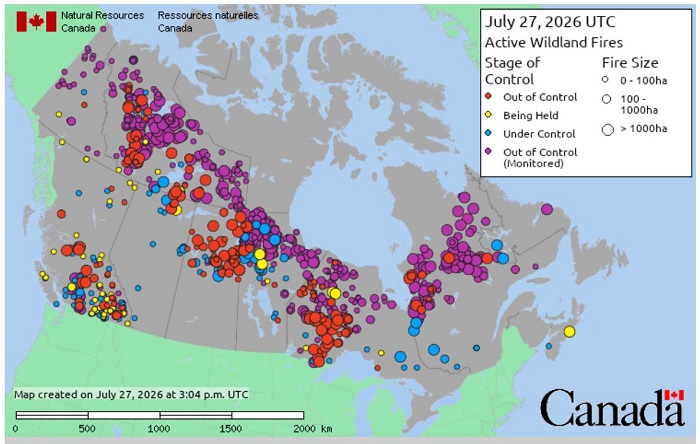
TORONTO – Active wildfires in Canada have once again surpassed the 900 mark (916 to be precise), spreading from coast to coast. As clearly shown on the map above (taken – at the moment of writing – from the website of the federal government’s Canadian Wildland Fire Information System, here), the entire country is being crossed by wildfire activity, with some blazes even merging and becoming increasingly destructive.
This is what happened with the two fires threatening the village of Clinton, in British Columbia, which merged late Saturday evening, one day after the Pear Lake wildfire destroyed several structures, including homes, on the outskirts of the community. An update from the B.C. Wildfire Service – according to Global News – reported that the Pear Lake and Fiftynine Creek fires had merged and continued their advance north and northeast of the Chasm area on Sunday, about 20 kilometres north of Clinton.
On Sunday, the wildfire service updated its mapping, indicating that the estimated size of the two combined fires, Pear Lake and Fiftynine Creek, had reached nearly 670 square kilometres. Meanwhile, the French Bar Creek fire, covering approximately 250 square kilometres, continued to burn further northwest, forming together with the others the wildfire complex known as “Big Bar.”
The Thompson-Nicola Regional District announced on Sunday that residents of 70 Mile and surrounding areas would be placed under an evacuation order due to the Pear Lake wildfire. Residents in the area were asked to prepare to leave their homes.
As of yesterday, several dozen evacuation orders and evacuation alerts were still in effect across British Columbia, mainly concentrated in the province’s central and southern Interior regions. The situation, therefore, remains a full-scale emergency in some areas, and weather conditions are certainly not helping.
Although rain fell in the Vancouver metropolitan area on Sunday, no significant precipitation is expected in the Clinton area, located about 350 kilometres further northeast. On the contrary, the region is experiencing prolonged drought conditions that are increasing the risk of new ignitions and encouraging more aggressive fire behaviour.
In such conditions, inevitably there are also consequences for air quality, with Environment Canada issuing alerts (here) of varying severity due to smoke that has spread into neighbouring provinces as well.
In the coming days, personnel from Yukon Protective Services, Alberta Wildfire and Mexico are expected to arrive in British Columbia to assist with firefighting operations against the more than 140 active wildfires burning across the province.
The situation is no better in the other Canadian provinces and territories. As mentioned above, at the time of writing (Monday morning/afternoon, July 27), the number of active wildfires across the country stood at 916, according to official data from the federal government and the Canadian Interagency Forest Fire Centre (CIFFC – here). Of these, 178 were classified as out of control, 556 as out of control but being monitored, 52 as being held, and 130 as under control.
The Northwest Territories are currently the hardest-hit area, with 215 active fires, followed by Ontario (159), Manitoba (154), British Columbia (142), Quebec (122), Saskatchewan (53), Yukon (25), Alberta (11), Newfoundland and Labrador (2), and Nova Scotia (2). Another 31 fires are burning within national parks.
Since the beginning of the year, Canada has seen 3.7 million hectares of land burned as of the time of writing, already close to the ten-year average of 3.8 million hectares. But it is still only July.
At the top of the article, the “map” of active wildfires in Canada as it appeared today on the Canadian Wildland Fire Information System website. Each dot represents a wildfire, while the colour indicates its stage of control: red for “out of control”, yellow for “being held”, blue for “under control”, and purple for “out of control (monitored)”