TORONTO – Thick smoke from Canada’s raging wildfires has already reached northwestern Europe, the European Union’s climate monitoring service said today. “Smoke originating from the wildfires in the Canadian provinces of Manitoba and Saskatchewan has been transported across the Atlantic, reaching Europe during the last few days with forecasts showing further smoke transport this week…” writes the Copernicus Atmosphere Monitoring Service (CAMS).
“Canada – continues the CAMS – has been experiencing a significant increase in the number and intensity of wildfires throughout May in the Canadian provinces of Saskatchewan, Manitoba and Ontario. The smoke from these wildfires has affected air quality locally. Moreover, several satellites have observed long-range transport across the Atlantic, with smoke reaching as far as Europe. An initial plume at high altitude crossed the Mediterranean region on 18-19 May with reports of the smoke reaching Greece and the Eastern Mediterranean. A second, much larger, smoke plume crossed the Atlantic during the last week of May, reaching northwestern parts of Europe on 1 June. Additional plumes are expected to reach the continent in the upcoming days.
According to CAMS forecasts, however, the predicted smoke transport is not expected to have a significant impact on surface air quality, as episodes such as these tend to occur at higher altitudes. “Typical effects of these episodes are manifested as more hazy skies with red/orange sunsets” the CAMS writes.
Mark Parrington, Senior Scientist at the Copernicus Atmosphere Monitoring Service, explains that “wildfires are a frequent occurrence in boreal forests from spring and through the summer months. Up to the beginning of June, our data is showing that central regions of Canada have experienced a very intense few weeks in terms of wildfire emissions. This data, and the fact that we are able to observe the smoke in Europe, is a reflection of the scale of the fires and impacts they have been having in Manitoba and Saskatchewan…”. And indeed the impact in these two provinces in particular is extremely worrying: new evacuation orders were issued Monday evening for La Ronge, Air Ronge and the Lac La Ronge Indian Band, while the forest fire situation continues to worsen in the rest of northern Saskatchewan.
The population of the areas evacuated on Monday evening exceeds 4,000 people, in addition to the approximately 8,000 residents already evacuated due to the worsening forest fire situation: in total, 12,000 people have already had to leave their homes in Saskatchewan, which in recent days declared a state of emergency, as has Manitoba (where evacuated people are 17,000).
Smoke alerts are also active in both the provinces of the Prairies, as also in Alberta and Ontario where wildfires are active too, while other fires continue to burn in British Columbia. Real-time updates in the “Wildfires” section of the Government of Canada website (www.canada.ca).
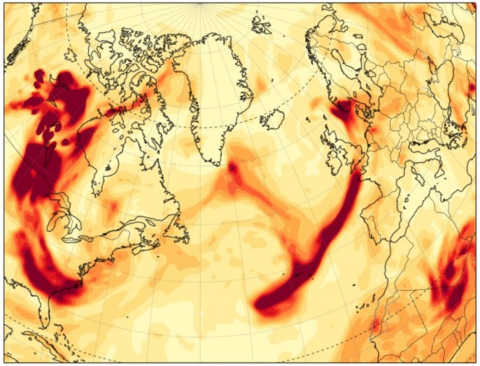
In the image above, published by CAMS, you can see the “streak” of smoke (here represented in “AOD”, Aerosol Optical Depth, i.e. the measurement that quantifies how much sunlight is attenuated by the agents present in the atmospheric column) that reaches Europe from Canada around 1 June