
TORONTO – For Ontario, the current wildfire season has already become the worst on record. We are only just past the halfway point of July, yet the blazes raging across northern Ontario have already scorched more than 7,250 square kilometres of forest, surpassing the previous record set in 2021, when the total burned area was slightly smaller. Therefore, the still ongoing year 2026 is already the worst one for wildfires in Ontario, at least since systematic records of burned area began in 1972.
The figure, however, is only a preliminary estimate and is expected to be revised once authorities are able to assess the full extent of the damage. In fact, as we reported in our previous article, yesterday (here), Premier Doug Ford said on Monday that the burned area had already reached 7,350 square kilometres of forest — or 735,000 hectares. It is a staggering number, considering that the average annual area burned in Ontario over the past decade is 210,234 hectares.
The vast majority of the burned area has gone up in flames over the past ten days, fuelled by an exceptional heat wave around Thunder Bay, where temperatures climbed to about 15 degrees Celsius above the seasonal average. The largest contributor to the record total is a massive wildfire covering 3,188 square kilometres north of Thunder Bay.
Fire crews continue working around the clock to contain the devastating blazes, which have destroyed entire communities and forced thousands of residents to evacuate. More than a dozen communities — most of them First Nations — have been forced to leave their homes.
Fortunately, recent rainfall has helped temporarily reduce wildfire activity across Ontario, but officials warn that the risk remains high.
“There hasn’t been enough rain in northwestern Ontario to significantly reduce the long-term wildfire risk,” Liam Buchart, a fire weather specialist with the Canadian Forest Service, told CBC.
Moreover, forecasts for August indicate that much of northern Ontario is likely to remain hotter and drier than normal. Although conditions may not be as extreme as those experienced in recent days, “a complete reprieve is not really in the forecast,” Buchart said.
The total burned area is therefore likely to increase substantially in the coming weeks. The preliminary estimates — compiled by Ontario’s wildfire agency and shared with the Canadian Interagency Forest Fire Centre (CIFFC), the non-profit organization that coordinates wildfire resources across the country — are expected to rise as more accurate assessments become available.
In addition, because Canada’s official wildfire statistics — known as the National Burned Area Composite — rely in part on high-resolution satellite imagery, the thick smoke produced by the fires is currently making it difficult to determine the exact extent of the burned area. Smoke remains one of the main obstacles to producing accurate real-time estimates. Only later, when visibility improves and satellite imagery can be fully analyzed, will officials be able to determine whether additional burned areas were missed or whether some areas initially counted were, in fact, left untouched.
Meanwhile, according to real-time data from the Canadian Interagency Forest Fire Centre, there were 890 active wildfires across Canada today at the time of writing this article (early afternoon, Tuesday, July 21, 2026): 192 were out of control, 45 were being held, 103 were under control, and 550 were being monitored. Excluding the Northwest Territories, where 208 wildfires were burning, Ontario had the highest number of active fires in the country, with 181.
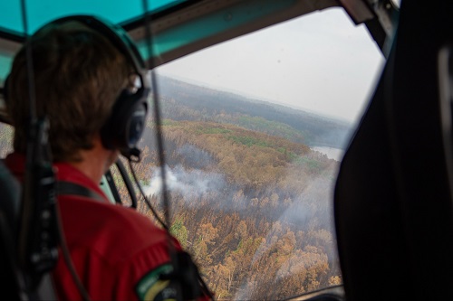
In the pic above, an air crew at work in Ontario (photo from Premier Doug Ford’s Twitter/X profile – @fordnation)

Comment
Comments are closed.